Knowledge Centre- Subject Index Main Help page |
Aerial Photography
by Tim Slater
Part 1 - The Pre-Cursor 1849 to August 1914
Part 2 - The Beginnings August 1914 to January
1916
Part 3 - Aerial Photography comes of age
Part 4 - The Uses for Aerial Photography
Part 1 - The Pre-Cursor 1849 to August 1914
At the start of the twentieth century the evolution of camera design and photography (fast exposures and camera miniaturisation, automation/remote control and stabilisation) led to two main uses for photographs taken from a tethered aerial platform; survey and observation, both of which had direct military applications. Survey provides the cornerstone of accurate mapping which when overlaid with observations; previous intelligence gathering and reconnaissance, provides military commanders with a two-dimensional representation of the area over which military operations are envisaged or planned.
The first successful experiments in photographic topography were carried out in 1849 by a French army engineer called Aimé Laussedat. Laussedat pioneered the use of aerial photography as a surveying tool to map the city of Paris. He used unmanned balloons and kites from which he suspended his camera. In the mid 1880s E. G. D. Deville, the Surveyor General of Canada, refined and adapted Laussedat’s techniques for use in the Canadian mountains. By comparing the terrestrial photographs taken from various locations and incorporating standard surveying techniques a third dimension was added to the mapping and this resulted in the first accurate contoured maps being produced. Deville’s third dimensional technique was improved in late 1883 when Cornele B. Adams, a US Army officer, was given a patent for a ‘method of photogrammetry’ that involved the capture of two aerial photographs of the same area with a camera from two different positions. The resulting stereo image was then used to create a topographical map. Twenty years before the advent of powered flight the utility of aerial photography in support of accurate map production had been clearly demonstrated.
The use of the nascent aerial photography capabilities was not immediately apparent to many military officers. None of the combatants in the Crimean war (1853-1856), the conflict closest to aerial photography’s birth, appear to have attempted to photograph from balloons. In Britain the War Office could not be convinced of the balloons potential consequently they were not operated at all by the British. The Civil War in the USA was the first large-scale conflict where balloons played a role on both sides. The first reported military application of aerial photography is believed to have occurred in 1862 during the Union siege of Richmond, Virginia. An aerial photograph of the town was taken from an observation balloon. Two gridded map-like prints were produced one for General McClellan, the Union commander, the second for the balloon crew who observed the activity taking place in Richmond from a height of 1,500 feet. Communication was established by telegraph and the balloon observers indicated movements within the town by using a grid marked on the photographs (Hamish B. Eaton, APIS Soldiers with Stereo: An Account of Army Air Photographic Interpretation, (The Intelligence Corps Museum, 1978) p. 1.). A British eye witness to the event, Captain F. Beaumont Royal Engineers (RE), who served with the Union Army’s Balloon Corps in the American Civil War, wrote:
‘I once saw the fire of artillery directed from the balloon; this became necessary, as it was only in this way that the picket which it was desired to dislodge could be seen.’ J. M. Bacon, The Dominion of the Air, (Project Gutenberg Ebook, 1903).
British Balloon Capabilities
Despite the evidence British moves towards balloon acceptance still stuttered. Two officers, Beaumont, and Captain G. E. Grover tried unsuccessfully in 1863 to persuade the British military to recognize the military value of balloons. They failed for two reasons, cost and the operational limitations of not being able to produce hydrogen in the field. However, in 1878, following a change of personnel at the War Office, Captains J. L. B. Templer and H. P. Lee were appointed to the Woolwich Arsenal with the task of constructing and trialing balloons for military use. By 1879 there were five balloons in British military service (Eaton, APIS Soldiers with Stereo. p. 1.).
In 1883, Major H. Elsdale, RE, whilst serving in Canada, made an experimental attempt at balloon aerial photography. Elsdale took photographs of the fortress at Halifax, Nova Scotia using a clockwork-operated plate camera that when an exposure had been taken triggered a mechanism that ripped the balloon fabric and brought the camera back to earth. In 1885 balloons were deployed with the British expedition to Bechuanaland and although Elsdale was present no mention is made of his aerial cameras. Figure 1 is a vertical aerial photograph taken by Elsdale in 1886 of the Balloon School camp at Lydd in Kent.

Figure 1. Balloon School Camp at Lydd in Kent 1886.
A School of Ballooning was formally established at Chatham in 1888, and was moved to Stanhope Lines, Aldershot in 1890 when a balloon section and depot were formed as permanent units of the RE establishment. The Boer war (1899-1902) saw an expansion in British military ballooning with a further four sections, including a photographic reconnaissance section, being authorised and employed in South Africa. The primary roles for the balloon sections was observing enemy troop movements and directing artillery fire. Some of their most important but less published roles was to improve the very poor maps the British had at the outbreak of war, to sketch Boer camps and battle dispositions and take the earliest aerial photographs. Figure 2 is an oblique photograph taken from a British balloon at 1,000 feet. The white patches on the image are smoke from exploding shells.
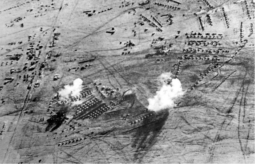
Figure 2. Boer War - British Camp Balloon Base (date unknown).
The Birth of the Royal Flying Corps
On the 17 December 1903 the Wright brothers flew the first heavier-than-air craft. Another type of aerial platform had become available. In 1908 on a demonstration flight in France Wilbur Wright’s passenger L. P. Bonvillain took the first photograph from an aircraft. The stage was set for a revolution in aerial photography.
The advent of heavier-than-air craft stimulated the British army’s aviation establishment and on 28 February 1911 an army order was issued creating the Air Battalion of the RE’s. The Air Battalion comprised No.1 Company (Airships) and No 2 Company (Aircraft). In October 1911 the British government was provided with a report on the French air corps exercises held at the ‘Camp du Châlons’ during August 1911. The author, Lieutenant Ralph Glyn, was attached to the newly formed Air Battalion. The report cited the main use of aircraft by the French as reconnaissance and control of artillery fire, but went on to highlight the successful use of aerial photography. As the Official History states; in 1911 the French air corps’ exercise provided an insight into:
‘. . . , almost all the uses [for aircraft] which later became the commonplaces of the war’. Walter Raleigh, The War in the Air Volume 1 (Oxford, Clarenden Press, 1922) p. 178.
The obvious importance of aviation and Britain’s perceived vulnerability to air attack led to the creation of a unified British Aeronautical Service called the RFC on 13 April 1912. The RFC comprised a Military Wing a Naval Wing and a Central Flying Training School. By 13 May 1912 the old Air Battalion had been absorbed into the RFC.
Early Aerial Photography in the RFC
During the early summer of 1912 the War Office sought volunteers from across the British Army to join the Military Wing of the RFC as ground personnel. One area that the RFC particularly wanted to improve was in the adaptation of current balloon photographic techniques and methods for use in aircraft. In August 1912 Frederick Charles Victor Laws, aged twenty five, transferred to the RFC from the Coldstream Guards after seven years of military service. He was accepted as an Air Mechanic (photography) 1st Class. Laws was to become one of the key influences in the development of British aerial photography during the First World War. Posted initially to No 1 Airship Squadron at Farnborough where within a few months he was promoted to Sergeant in charge of the photo-section, he soon found that aerial photography was not treated as a priority. Dismayed not to be working with aircraft it was pointed out to him by his Commanding Officer that only airships were involved in photography at that time. The majority of the early photographs were oblique but by mid 1913 the British experience had demonstrated the need for a camera that could be fitted to an airship or aircraft pointing vertically downwards, such a camera would need to be able to take successive vertical photographs that ensured continuity of cover or overlap. During early 1913 Laws had been the camera operator involved in the seminal airship flight that captured an overlapping series of aerial photographs along the Basingstoke Canal. This series of photographs proved a milestone in the application of aerial photography to mapping. The camera used had been the first specially designed and fixed Watson Air Camera (Figure 3).

Figure 3. The Watson Air Camera 1913
During the spring of 1913 the Naval Wing of the RFC took control of all the British airships. Laws who was more interested in aircraft than airships asked to remain in the Military Wing and was posted along with his whole photographic section to the Experimental Flight at Farnborough commanded by Major Herbert Musgrave. The unit at Farnborough carried out experimental work with wireless, bombing, photography and artillery co-operation. In the twelve months from the spring of 1913 to 1914 Laws and his photographic team had many flying opportunities and learnt a great deal about emulsions, filters, and the effect of shutter speeds. The greatest challenge was the fitting of the Watson air camera into an aircraft, the first being fitted into a Henri Farman. F. C. V. Laws, Looking Back - Paper read by the Author at the Photogrammetric Society's Meeting on 18th November, 1958, The Photogrammetric Record, Volume 3 Issue 13, (1959) pp. 25-29.
In parallel with the experimental photographic work being carried out by the Flight at Farnborough the aircrew of 3 Squadron RFC, realising the possible value of aerial photography to military reconnaissance work, purchased their own cameras and adapted them for use in the air. The aircrew of the squadron experimented and successfully developed a system of developing the glass plate negatives in the air, so on landing they would be ready to print. During the summer manoeuvres of 1913 the squadron tested their techniques and, early in 1914, produced examples of their work, a series of photographs showing some of the defences of the Isle of White and the Solent. The hand held press-type cameras they adapted and used, with a 6-inch lens, became the camera type used most frequently by the RFC until 1915 (Raleigh, The War in the Air Volume 1. p. 250.).
Netheravon Concentration Camp - June 1914
With the threat of war looming, the RFC gathered in June 1914 at a ‘concentration camp’ at Netheravon, Wiltshire for a trail mobilisation and practice flying, that included aerial photography, over Salisbury Plain. At the end of July, Laws was mobilised and transferred to 3 Squadron at Netheravon. Flying as a passenger in a Henri Farman piloted by Lt. T. O. B. Hubbard he set off from Farnborough to join 3 Squadron with the Watson camera installed in the nose of the aircraft. At 3,000 feet over Odiham the aircraft’s engine failed, forcing a crash landing that wrecked the aircraft and camera but fortunately left Laws and Hubbard unharmed. The RFC had lost its sole aircraft adapted to carry a fixed air camera.
Three days later the art of photographic interpretation within the British military was arguably born. Laws again a passenger in a Maurice Farman aircraft, took photographs using a press-type camera of a parade taking place at Netheravon. When Laws developed the photographs he noticed that he had captured on the photograph a Sergeant Major chasing a stray dog off the parade ground. The tracks of both the dog and the Sergeant Major were clearly visible in the grass, owing to the angle of the light on the crushed blades. (Laws, ‘Looking Back’, pp. 25-29.). Samples of the photographs taken by the RFC during their practice flying were published in Flight Magazine during June and July 1914. Figure 4 illustrates the high quality of one of these photographs, the circle on the photograph highlights four wagons the target of this particular reconnaissance mission.
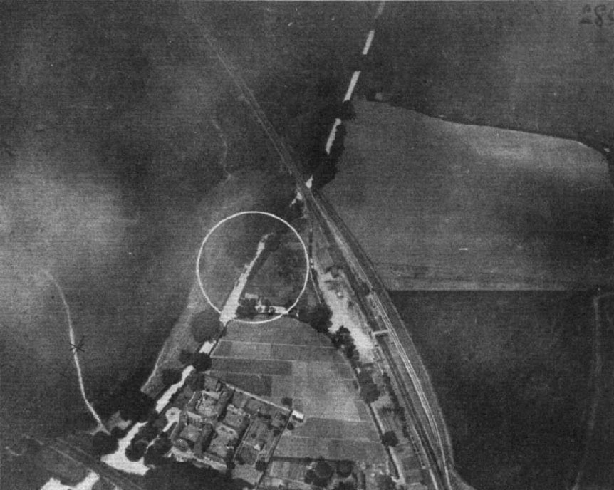
Figure 4. Reconnaissance target (4 wagons) 15 Jun 14, 2,000 feet.
On the 7 August 1914 Laws left Salisbury Plain for France. He expected to be fully occupied taking photographs of enemy positions, the reality was somewhat different. The RFC that deployed to France, equipped with six hand held ‘Aeroplex’ cameras with 12-inch lenses (up to five ‘Pan-Ross’ cameras followed soon after), had little appetite and arguably little need, at least initially for photography (NA: AIR1/724/91/6/1 History of Photography in the Air Branches, 1914-1918).
Part 1 - The Pre-Cursor 1849 to August 1914
Part 2 - The Beginnings August 1914 to January 1916
Part 3 - Aerial Photography comes of age
Part 4 - The Uses for Aerial Photography
Knowledge Version 2 1.1