Knowledge Centre- Subject Index Main Help page |
Great War Map References- How good are they? |
A feature of TrenchMapper it that it can convert a map reference to the equivalent latitude & longitude coordinate with remarkable accuracy and vice-versa, but before a reference is given too much weight, some other factors need to be considered.
- If a Great War point was recorded using a map reference, how accurate is that likely to be?
- How well could a soldier be expected to record their position?
To evaluate these, one must take into account map grids, poor planimetry, reference resolution, how to use a map reference and the lack of local markers
Problem 1:- Map grids
Early Provisional or First edition (Edition A) maps in 1915 had the same grid number and letter system as later maps but one that was displaced. Map references recorded using these early maps will not match with those on later ones nor will they give the correct result in TrenchMapper. It would take detailed work to discover where a specific point was but it will not be at the same place if that early reference is used on a later map.
Problem 2:- Poor planimetry
An additional problem is the poor planimetry of early maps, i.e. low geometric
accuracy. Even as late as September 1915 most maps were affected, even those
used for the Battle of Loos, e.g. note the different line of the roads in
square 27 in Figure 1 and the distortion of a map sheet in Figure 2.

Figure 1. Maps from mid 1915 and December 1915 map, 1:10,000
Maps in TrenchMapper are georeferenced to modern maps but most of the 1915 maps cause a problem, they do not fit that well, some not at all. Modern software is used for georeferencing, this uses geometric transformations of various types to match the degree required for each map. The most extreme is Thin Plate Spline which can distort a map locally to counteract the real local distortions of the old map. Figure 2 shows a typical 1915 trench map distorted to match the underlying modern map, its grid lines and outline are no longer rectilinear.
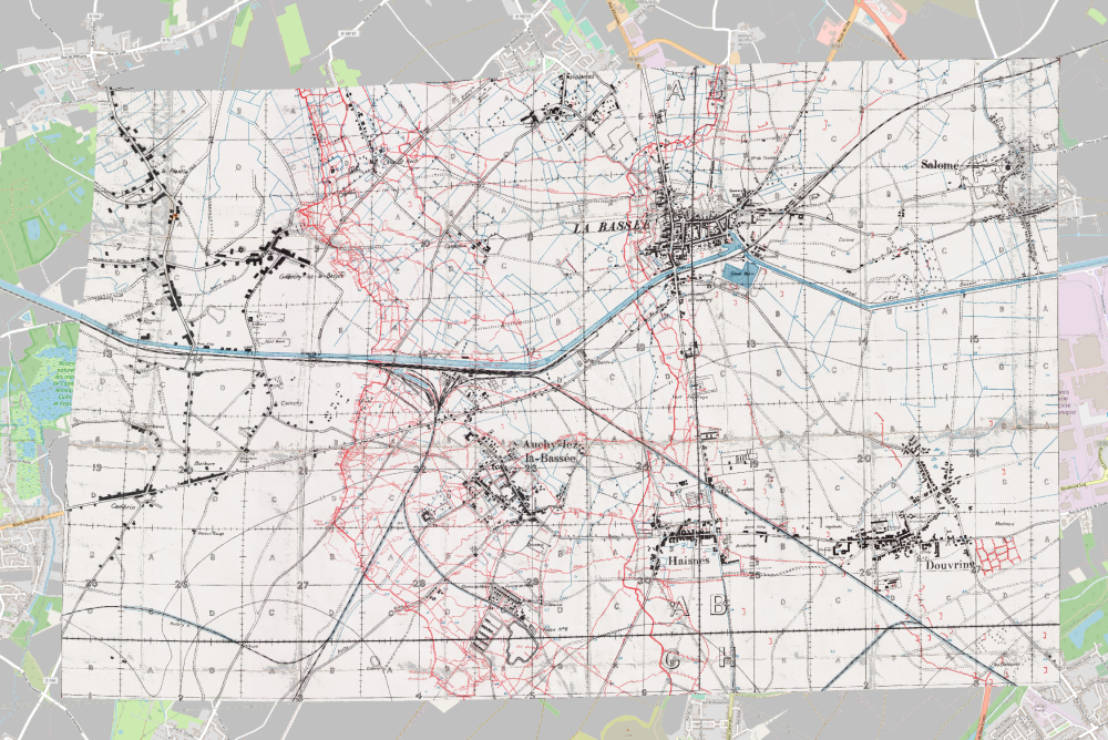
Figure 2. The distortion required to make an early 1915 map
fit the modern map. A transformation known as Thin Plate Spline has been applied,
the roads and places now fit but the error in what is supposed to be a rectangular
grid system is plain to see.
Problems 1 and 2 together:-
As an example, take a point of the Loos battlefield opposite Les Briques
Farm in September 1915. This was the scene of the failed attack on the 25th
September despite the first British use of poison gas, troops of the 1st Middlesex
only got halfway to the German trenches there. If a soldier was pinned down
and wished to report his position, he may take a bearing on Cuinchy Church
tower and another on the tower of St. Martin's in Auchy-lez-La-Bassée.
Say the Grid bearing to Cuinchy Church was 336° and Auchy was 72°,
plotting those on the best map available at the time (TrenchMapper id=m_5_000569,
Figure 3), gives a map reference of 36c.A.27.b.63.45. Despite being the best
available, it still used the old grid position displaced from later maps and
the planimetry was poor. If in researching this report, these same bearings
are plotted on later maps, they result in different references depending on
the date of the map as Table 1 shows.
| Edition | Sheet date | Cuinchy 336°, Auchy 72° | Plotted Reference |
| Provisional | [early] 1915 | Old grid origin | 36c.A.27.b.63.45 |
| 6 | Dec-15 | New grid origin, poor planimetry | 36c.A.28.a.25.19 |
| 10A | Dec-17 | New grid origin, good planimetry | 36c.A.28.a.17.17 |
Table 1, the same bearings applied to different maps.
36c.A.28.a.25.19 from Edition 6 and 36c.A.28.a.17.17 from Edition 10A are
41 yards apart owing mainly to improved planimetry i.e. better plotting of
the geometry. 36c.A.27.b.63.45 from the Provisional Edition map used during
the Battloe of Loos is 301 yards from 36c.A.28.a.17.17, a massive error between
old and new maps.
It is very clear that map references must be plotted on maps that best match
the date of the report.

Figure 3, point showing the centre of the 1st Middlesex front on
sheet 36C NW 1 & 36C NW 3 Secret Edition A, Trenches corrected to 10-9-1915
& 25-8-1915. TrenchMapper id=m_5_000569. Grid bearings.
Problem 3:- Reference resolution
This refers to the resolution of the reference itself, either to +/- 5 yards
or +/- 50 yards. They come in two forms, one with single last digits and the
other with double digits.
36.A.12.56.78 will give a reference to +/- 5 yards whereas almost the same
point written as 36.A.12.6.8 is within 50 yards. In the first example, the
56 (actually 5.6) is rounded to 6 and the 78 (7.8) is rounded to 8. Strictly
such references do not define a point exactly but a square but many did not
use them that way, see Problem 4. See the TrenchMapper Knowledge Centre article
How to Read a Trench Map for a full description.
Problem 4:- How to use a map reference
The map reference 28.J.20.d.5.1 is given with the last two figures as single
digits which means it defines a square 50 x 50 yards with its south western
corner at 28.J.20.d.5.1. The point in question could be anywhere in that square.
That is the strict view of such a reference but most would have used the map
reference as the actual point. This is the same with modern day OS maps, a
reference defines a square by its SW corner but most people either do not
use it in this way (or perhaps may not quite understand that). Did the soldier
who recorded the point use the common but unofficial way or did he follow
the instructions on the map? This introduces a further level of uncertainty.
Figure 4. The instructions included on many regular trench maps
says "A point may thus be described as lying within Square…etc."
From direct observation of reported points, most uses of the map reference
system ignore that part of the instructions and use the reference taken as
the point itself.
Problem 5:- Lack of local markers
The accuracy of a recorded position will depend on the conditions around
the point in question. If the point was in an area where the trench lines
had not moved very much, were in good condition and were clearly marked, the
given map reference is likely to be accurate, at least to the 50 yard resolution
as given by most map references. During the war there were pickets all along
the line for use by artillery to fix their position, if the point in question
could be fixed relative to one of those, all well and good, but much of the
time, this would not have been the case.
Take for example John George Haywood of the King's (Liverpool Regiment). He
died on 4th December 1917 aged 35 and is buried in Hooge Crater Cemetery near
Ypres but he did not die there. His body was found at map reference 28.J.20.d.5.1,
a point in what was Stout Wood about 4 miles east of Ypres or 1.5 miles south
east of where he now rests. How accurate was the point when it was recorded?
Was the recording soldier actually at that point and how would they have known
their position? The local area had been very heavily shelled so most key points
would have been destroyed.
He was found about 1,900 yards from map reference 28.I.24.d.8.4, the site
of Tor Top Tunnels, a point clearly marked at the time with a map reference.
That is too far away to be really useful but other trench names or points
with similar signs may have helped the exhumation team, provided they were
shown on the map.
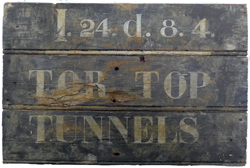
Figure 5. Point marker
Trenches in this area in 1917 and 1918 were not so much lines as elsewhere
but semi-organised systems of shell holes. This means there was far less likelihood
of named trench junctions or other quick key points for the recovery team
to use. They may have needed to rely instead on a compass bearing from a distant
object or building. The point is, there is uncertainly in the method of fixing
a point and this applies to all reported points and positions.
The map showing where John was found looks optimistic, it shows clear boundaries
to Stout Wood, tracks and even buildings but the reality was the landscape
was a field of shell holes as shown by the aerial photograph which was taken
97 days before the valid date of the map. Both cover exactly the same area.
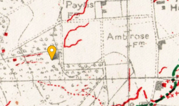
Figure 6. Stout Wood where John was found at 28.J.20.d.5.1. Trenches
corrected to 22nd Dec. 1917, 18 days after he died.
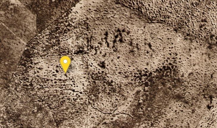
Figure 7. Exactly the same area as Figure 5, 17th September, 79
days before John died. The outline of the wood or the tracks are barely visible
but may have been just usable to determine position but perhaps not on the
ground in the mud.
There were not that many clearly defined points nearby, possibly the corners
of Stout Wood could have been determined and the map references noted from
the map, likewise the remains of Ambrose Farm 250 yards East or Lone House
630 yards West. Without some sort of very local marker that could be used
to fix a point, the obvious means would be to use two or more compass bearings
from identifiable points, maybe still existing church towers despite damage.
The way this was done is described in the Manual of Map Reading and Field
Sketching 1912, part of which is reproduced below, the whole booklet is available
as a download from the Extras section of TrenchMapper's Knowledge Centre.
The method used is known as Resection.
Resection
To find the location of an observer by bearings to distance objects is known
as resection. The reverse is intersection when an unknown point is determined
by bearings to that point from a distance.
Two or more bearings to distinct points are taken and drawn on the map and
where they cross is the point of interest. Whilst it is possible to calculate
the position by using Cassini's Method or the Tienstra formula, this article
and the Field Sketching Manual only uses a more direct graphical solution.
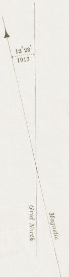
Using resection with a map means dealing with the three Norths, Magnetic,
Grid and True. When resecting a point it does not matter which is used provided
they are understood and not mixed. The grid on Great War maps, like that on
modern OS maps, does not align with True North. In the case of the map example
here, Grid North is approximately 0.8° or 0° 48' to the West of True
North and does not change over time. Magnetic North was 12° 23' West of
Grid North in 1917, (in modern times this would be shown as -12° 23')
and declines slowly, in 2023 it is closer to 1° East. So to resect a point
using the grid to measure bearings from, it is best to convert a magnetic
or compass bearing taken from a distant object and convert that to the grid
bearing. The difference between a magnetic bearing and True North is known
as the magnetic variation (or sometimes, declination) but to resect a point
it is most convenient to use the difference between magnetic and Grid North.
An added complication is compass variation, the error in the design and manufacture
of the compass itself. In modern compasses this is rarely taken into account
(except in certified marine and aviation compasses) but the Manual of Map
Reading and Field Sketching 1912 requires users to determine that variation
repeatedly to ensure accuracy. This was done by taking bearings from a known
point to a distant known point and plotting the result on a map.
There are all sorts of rhymes or acronyms to remember whether to add or subtract
magnetic variation but most are more confusing than a simple equation. Where
D=Compass variation (often ignored), V=magnetic variation, G=Grid bearing,
M=Magnetic bearing (or the compass reading),
G=M+D+V where a Westerly variation is always negative, Easterly is always
positive.
So in 1917, if a Compass bearing of 87° was recorded to a point, its Grid
Bearing would have been 84° + -12° 23'=71° 37' (ignoring the compass
variation).
The same point now would be 84° + 1°= 85° with a 1° (easterly)
magnetic variation.
 |
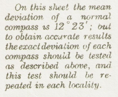 |
Figure 8 and 8a. Magnetic variation from the map in Figure 5
How accurate does your bearing have to be?
Trigonometry can be used to calculate bearings and distances but a useful rule-of-thumb is the 1 in 60 rule. If an object is 60 metres away, a 1 degree angle will subtend 1 metre quite closely. An object 600 metres away will subtend 10 metres etc. in the ratio 1:60. By this rule, a compass that can read reliably to one degree can be used to find a point within 5 metres for objects 300 metres away. If the compass could be relied upon to half a degree, it would be 300/60/2= 2.5 yards. By calculation, the distance is 300 x TAN(0.5)=2.62 yards, but the difference in this context is negligible.
Map Reference 28.J.20.d.5.1
Despite the destruction, the remains of the Tower of the Cloth Hall in Ypres
may just have been visible 7,000 yards away at a Grid Bearing of 289°.
Using the 1 in 60 rule (see below), a bearing to an accuracy of half a degree
would subtend a distance of 7000/60/2 or about 58 yards, i.e. would help fix
the point to within that distance at right angles to the bearing. A better
result would have been obtained if nearer local landmarks were available,
so if Gheluvelt Church tower was visible it would have been on a bearing of
about 80°, 1662 yards East. The rule of thumb error across that bearing
would have been 1662/60/2 or just under 14 yards.
So had the reference been quoted as 28.J.20.d.51.13, i.e. to a resolution
of 5 yards, would that have made the actual point within +/- 5 yards? Without
clear and accurate local markers as fixed points, a 5 yard reference would
have made no sense using just a compass. It cannot now be determined what
reference points were actually used to record where John lay but in such a
shell crater field it is very unlikely to have an accuracy better than 50
yards.
A problem using a compass in a war zone
In a paper presented to the Royal Geographical Society in 1919, Lieut.-Col. H. S. L. Winterbotham wrote:-
"The magnetic compass is an instrument which should be used as little as possible where accurate results are wanted. In the area of operations there is so much old iron lying about that one can never use a compass with confidence. Nevertheless there are occasions, and many of them, when the gunner is compelled to fall back upon its use, and for that reason Field Survey Battalions have made special arrangements throughout the campaign for testing and reporting on individual compasses."
Colonel Winterbotham was one of the key figures in the British mapping and
surveying effort during the war. His paper is downloadable from the TrenchMapper
site under Extras.
This means that bearings taken from a point in a heavily contested area may
be quite misleading owing to the large volume of magnetic material in the
soil. In some areas the amount of such material in the ground may still affect
an accurate compass.
Why use a compass rather than a GPS?
A good reason is to better understand the difficulties encountered during
the Great War for a soldier to define and record a point. The Royal Engineers
Field Survey units had theodolites and other means to define points very accuratly
but most reported map references were not set down in that way. Many would
have been set using a standard military prismatic compass.
Another good reason to use a compass is as an act of remembrance. Soldiers
at the time had no GPS, they relied on landmarks, pickets and raw map reading
skills to determine a position. Many documents and some maps produced at the
time showed local churches as sketches so they could be identified for use
in finding a point.
Finding your position using much the same way as back then is also a means
to appreciate the accuracy or lack of accuracy in positions reported at the
time. If the position of Black Watch Corner is given as 28.J.15.b.00.90 that
implies an accuracy of 5 yards- but is that right? Was the soldier that good
at finding postions?
GPS is wonderful, it is quick, easy to use and can be linked to a wide range
of devices and applications. A conventional consumer grade GPS receiver or
those used in many phones will on a good day give positions to within 5 metres-
sometimes better, sometimes worse especially in wooded areas. Mapping grade
receivers can give an accuracy to half a metre but are expensive. Survey grade
receivers can give an accuracy of centimetres but are very expensive and require
a lot of knowledge and training to use or at least to interpret the results.
But this is not the point with map refernences, no GPS can compenstae for
an inaccurately plotted reference.
So why still use a compass? An inspection of TrenchMapper will show the problem.
The maps are georeferenced against a modern map and the fit achieved is often
truly amazing, provided that maps drawn in 1916 or later are used. Those drawn
earlier show considerable error and do not fit the modern map at all well.
For this reason, taking bearings from known points can sometimes provide a
more accurate ground placement than a GPS, not because of GPS limitations
but because of the geometry of the map and the way that references were determined
at the time.
Take for example Laventie Church in the British area of the Battle of Loos.
On early maps its position was wrong by 150 yards in latitude but as maps
were then drawn by using such prominent features as reference points, points
close by them can still be located with more confidence by using bearings
to or from that point using old maps rather than by a point from a georeferenced
map and GPS. In TrenchMapper, great efforts have been made to mitigate these
errors so early 1915 maps have been fitted to the modern map by sophisticated
techniques. This was not available at the time so if a position was determined
by use of points like Laventie Church, a different solution is required.
Compasses
There are many types of compass available but not all are suitable. To be
useful in finding a point in the landscape, an accuracy of half a degree or
better is useful along with a precise means to point or sight to a distant
object.
It feels very fitting to use a genuine military prismatic compass from the
Great War era but these are getting harder to find and the market is flooded
with fakes. It takes quite an effort to find a genuine one and fake ones may
not offer useful accuracy or durability. However, such models are still made,
an example being the Francis
Barker M-88 now made by Pyser Optics. It has a useful accuracy, is easy
to use and looks like those used in the Great War.
An alternative is to use a modern accurate compass such as the Suunto
KB-14. These are more expensive but offer the same or better level of
accuracy whilst being a lot quicker and easier to read and are much smaller.
Even more expensive are some of the models made by Brunton like the Pocket
Transit but these are also very widely faked.
Plate compasses as used for normal map reading exercises or orienteering cannot
be pointed or sighted with sufficient accuracy at a distant target, they do
not have a sight or other means to achieve that well enough. Lensatic examples
as commonly used by the US military are good for navigation whilst out walking
but do not have a ready means to sight a distant point with sufficient accuracy
despite having a sighting arrangement. Others are made mainly as ornaments
or objects of interest. Sadly, a good compass is not cheap.
An electronic compass is very unlikely to be useful as most have no adequate
sighting and worse, they need calibrating just before use and have no means
to check if the calibration has worked properly. The versions in most mobile
phones are far from suitable.
(The author has no commercial ties of any nature with any of the companies
or products listed here.)
Other considerations
Relying on a map reference to find "the exact spot where Granddad fought"
requires more thought and consideration than simply typing it into TrenchMapper
and relying on the outcome. The Tor Top tunnels position from the sign should
be reliable, such signs would have had their position checked by the Royal
Engineers Field Survey units, so converting 28.I.24.d.8.4 in TrenchMapper
will yield a reliable result to its implied +/- 50 yards. Should an archaeological
dig search for such reliable points, exploratory trenches would still be required
to find them. A reference to +/- 5 yards implies the soldier at the time had
the means to find position that well, possibly from artillery pickets, trig
points or known reference points, but some may simply be optimistic, e.g.
if the soldier thought his positioning was within 10 yards he may have been
reluctant to use a +/- 50 yard reference.
The issue of positional accuracy is slightly obscured by the georeferencing
in TrenchMapper. The Report on Survey on the Western Front (available in TrenchMapper's
Knowledge Centre) defines the absolute accuracy of a point location to be
+/- 20 yards, i.e. its latitude & longitude coordinate on the map, but
it says that relative positions between points are within +/- 5 yards. This
suited the artillery as they did not use absolute postions. As modern georeferencing
techniques are used in TrenchMapper, the absolute positions will be better
because the map is fitted and distorted to fit modern maps. This may not be
obvious. It should also be borne in mind that on a 1:10,000 map, a feature
1mm wide on paper is 10 metres wide on the ground. A typical trench map will
have grid lines 3 yards wide in scale so a reference to +/- 5 yards is only
just a little more than a grid line width. Can such references be relied upon?
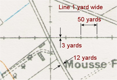
Figure 9. Distances on a 1:10,000 map
Conclusion
It is possible to use Great War maps and their map references, with or without the aid of TrenchMapper's conversion algorithm, to stand close to where Grandpa died but it is not possible to be certain that you can stand "on the very spot". Such considerations do not of course affect the act of remembrance, merely the geometry.
Howard Anderson, January 2023
Knowledge Version 2 1.1