Knowledge Centre- Subject Index Main Help page |
Trench Maps:- A comparison of survey accuracy
Western Front
All examples are parts of British Sheet 36C NW1.
These examples show the extent of the map accuracy problem encountered by the British army even as late as the Battle of Loos in September 1915. Example 3 shows part of a rare secret edition of a map of the Northern part of the British line, one of just a few showing British trenches and represents the best available at the time. One of the problems concerning the conduct of the battle refers to inaccuracies in the mapping that caused difficulties with artillery.
At the start of the war
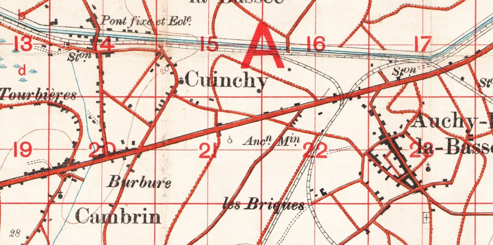
There were no adequate maps available in 1914 and most of early 1915, at least none suitable for trench warfare. For the situation in Gallipoli, see below. Because of that, maps were hurriedly prepared and the source of their geometry was the French 1:80,000 maps as example 1. This introduced large errors. Examples 2 & 3 show these early maps, compare the draughtsmanship of the town of Auchy-lez-la-Bassee and the depiction of the buildings as black blocks as copied from the French map. By 1917 in example 4, the style had changed to a more detailed one, i.e. it had been re-surveyed.
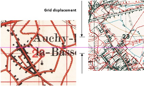
Note also the grid line position compared with later editions, the centre of square 23 runs through the North of Auchy-lez-la-Bassee but in later editions with better accuracy, the same grid line passes more than 500 yards further North.
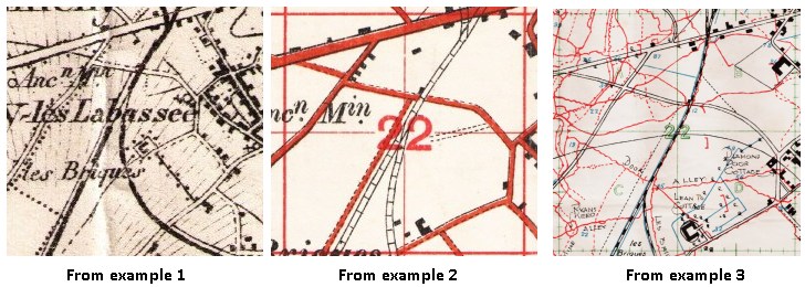
In the early maps, various features are not shown in their correct positions relative to each other despite the displaced grid, the railway junction immediately to the West of Auchy-lez-la-Bassee in square 22 shown in examples 1 & 2 differs even from the (less than accurate) example 3.
Later in the war
By 1917 as shown in examples 4 & 5, the railway junction is then shown in the correct position relative to the town and the grid and the modern map. The left hand of the two main streets in Auchy-lez-la-Basse that runs NW to SE is called Rue Marceau Gloriant in what is now Auchy-les-Mines. In the early maps Rue Marceau Gloriant is shown with a slight bend about halfway up the town, whereas in later editions it is shown as having a more distinct bend in the road. The railway junction is approximately level with this bend in Rue Marceau Gloriant.
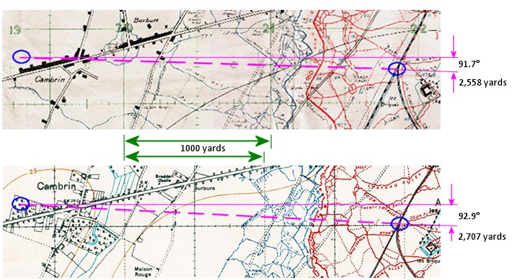
Example 6. made from example 3 from 1915 and example 5 from late 1917. The range and bearing from the Cambrin Wood to the railway junction are significantly different as are other details such as the crossroads at Burbure.
Had the artillery been tasked with bombarding that railway junction from the very small wood immediately West of Cambrin (a wood that is not even depicted on the 1915 maps), then scaling from the map the junction would be 2,558 yards from the battery at a grid bearing of 91.7°. Measured from the same points on a 1917 map and ignoring the grid displacement, the range would be 2,707 yards at a grid bearing of 92.9°. This would give a point 159 yards from reality, a clear miss. Here the location with the crossroads in Cambrin and the railway junction location is scaled and lined up. Also note the grid displacement and that the 1915 map used was the best map available for the actual battle of Loos. There are numerous other inaccuracies e.g. the location of the crossroads at Burbure just to the East of Cambrin.
A transcribed Great War document on maps for artillery and artillery boards is available here.
An import result on the use of this website
All this means that if a trench map reference is given for a location taken from these earlier maps, it cannot be used to determine a position on later maps and will give radical errors if used to determine the WGS84 position (i.e. GPS latitude & longitude) with the aid of the accurate map reference->WGS84 calculator on this site. The best that can be achieved when using one of these older trench map references will be to draw sight lines from the position on the older map to prominent features, i.e. the ones that would have been used by the soldier at the time when finding their position and hence reference, then drawing the same sight lines in reverse on a more accurate map.
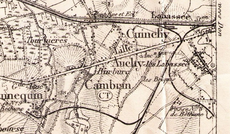
Example 1. Section of French 1:80,000 Arras (NE) sheet, published in 1889. M_027099.jpg
Example 2. Section of British 1:20,000, GSGS 2742, third edition, B Series 1915. M_026081.jpg
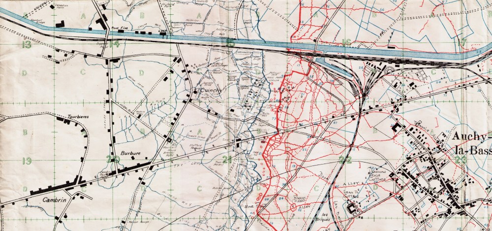
Example 3. British 1:10,000 Secret edition A, trenches corrected to 10-9-1915 & 25-8-1915. M_5_000569.jpg
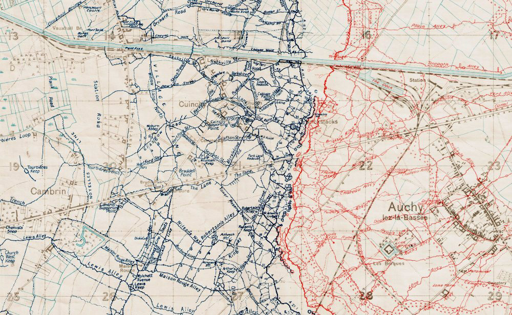
Example 4. British 1:10,000, GSGS 3062 Edition 8A, secret. Published April 1917. M_013800.jpg
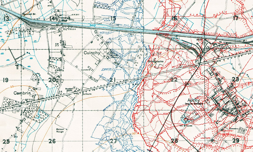
Example 5. British 1:20,000, GSGS 2742 edition 10A. Trenches corrected to 15/11/1917. M_000565.jpg
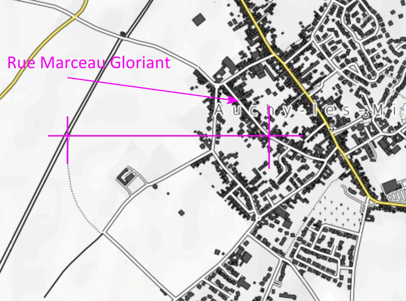
Modern Open Topo map showing the railway junction approximately the same level or latitude as the bend in Rue Marceau Gloriant, in Auchy-lez-la-Bassee (now called Auchy-les-Mines).
Gallipoli
The mapping situation in Gallipoli was in many ways worse than for the Western Front.
Some of the detailed maps showing trenches are headed "sketch" or "diagram" indicating their lack of survey accuracy. When these are georeferenced on top of a modern map, many discrepancies are found.
Georeferencing of these maps on this site was accomplished using a polynomial fit using many GCPs, Ground Control Points, but where many such points like churches are available on the Western Front, far fewer reliable points can be found on Gallipoli owing to the nature of the terrain in 1915- mainly rural. Even the towns like Krithia bear little resemblance now compared with 1915. It was found that when using prominent points like Lone Pine as a GCP, even then significant differences between maps were discovered. During the georeferencing, some coastal features were used as GCPs but coastal erosion limits their usefulness. Sadly, most Gallipoli maps do not have the topographical accuracy of maps on the Western Front so care is required if a GPS position is required.
For that reason, 43 Turkish Post Evacuation maps are available. To gain a reasonable GPS position for a feature of interest it is best the find that feature on an allied map then compare that point with one on the Turkish maps and adjust it relative to other features. That map will give a more reliable coordinate. Even taking that into account, the contour lines are not of a modern standard so care is advised when seeing the position of features such as a gully or a nullah as shown by contours.
Turkish Post Evacuation maps
Very shortly after the Allied evacuation of the Gallipoli peninsula, Brigadier
General Mehmet Sevki Pasha conducted a survey of the battlefields. The resulting
series of 43 maps were produced at a scale of 1:5,000 on the Bonne projection
using the Dome of Hagia Sophia as Prime Meridian. They were enlargements from
the Turkish 1:25 000 war-era maps and show Ottoman and Allied trenches, cemeteries,
camps, barbed wire and other features.
Post war, sheet 17 of this series covering the Anzac/Ari Burnu area was used
by Charles Bean, Australia's official historian. He was assisted by a number
of people including the Turkish officer Major Zeki Bey.
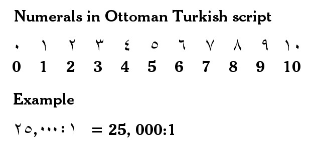
Ten years after the Great War, Mustafa Kemal Atatürk oversaw a large
change in Ottoman Turkish language, script and numerals. On these Post evacuation
Maps are the older form of numerals used before this change, here is a key
to interpret those.
Knowledge Version 2 1.1